
Agricultural land abandonment is an increasing problem and the Comunitat Valenciana Region is one of the most important citrus producers suffering this problem. For this reason, Campus de Gandia researchers from the Universitat Politècnica de València (UPV) have carried out a study that proposes the use of high resolution images and machine learning techniques for remote sensing of abandoned citrus plots.
“Remote sensing can provide very valuable information for the control, monitoring and management of agricultural plots,” said Sergio Morell, Campus researcher. “Traditionally, agricultural maps have been generated through photo-interpretation of orthophotos or through field campaigns. But today, remote sensing has become a powerful tool for obtaining land use maps that can replace the creation of manual maps with a more efficient use of personal resources and greater immediacy ”.
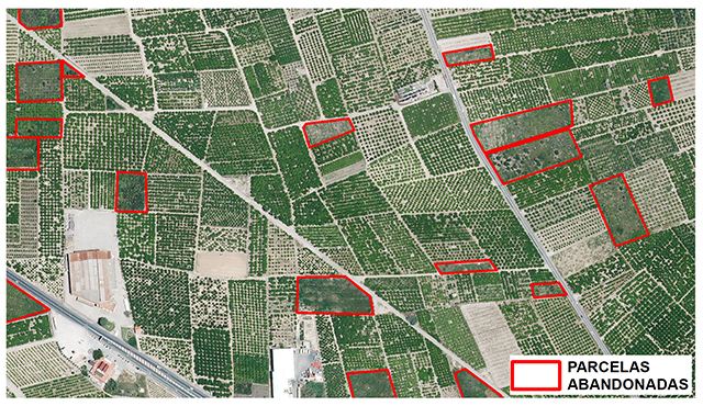
The study, carried out by Morell alongside fellow experts in remote sensing, María Teresa Sebastiá, and Javier Estornell, from Campus Gandia, demonstrates the difficulty in detecting abandoned citrus plots through the images from the Sentinel-2 satellite of the Copernicus program of the European Commission, and proposes the use of high resolution images. The difficulty in our area “is due to the small size of the agricultural holdings, the considerable spatial fragmentation and the minimal spectral differences between abandoned plots and producing plots.”
In the study, published in the journal Remote Sensing and which is also the result of Sergio Morell‘s doctoral thesis, a methodology was developed for the detection of abandoned plots and showing that high-resolution aerial images with four spectral bands generate more accurate results than the Sentinel-2 images for identifying small-sized abandoned citrus plots.
NEW APPROACH
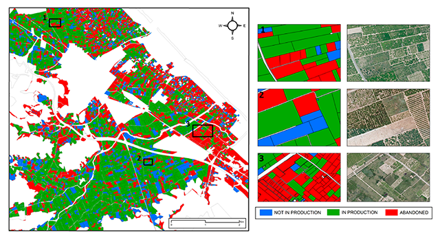
Land abandonment has been studied in the remote sensing field. However, until now there had been little study and abandoned citrus-growing lands had not been geolocated with this level of detail. As Morell details, “the proposed methodology combines remote sensing and machine learning techniques that permit agricultural plots to be classified into three categories (abandoned, productive and non-productive) based on spectral and textural information derived from a high-resolution image. The methodology obtained an overall accuracy of the plot-based classification of 95% in the main study area and 93% outside it.” For Morell, “the study offers a new approach for detecting land abandonment in small-sized woody evergreen crops.”
In addition, the precise identification of land abandonment offers useful information “to evaluate the effectiveness of agricultural policies, creating citrus inventories and making annual yield estimations, for landscape and water resource management, among others.”
APPLICATION IN OLIVA
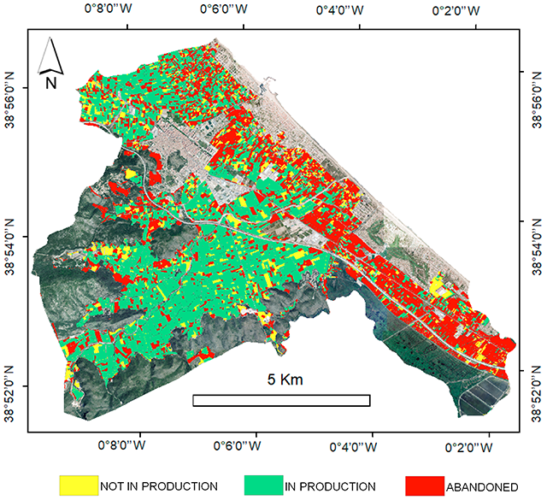
The main study area is in the municipality of Oliva. The town covers an area of 59,600 hectares, 50% of which is available for agriculture (95% citrus). However, the unfavorable results of the Valencian citrus campaign in the European market, the weaknesses of the sector itself together with urban expansion and tourism compete with agricultural land uses and are promoting the land abandonment in this municipality. According to the initial results, “approximately 30% of the agricultural plots in Oliva are abandoned. These results demonstrate the need to avoid underestimating the abandoned area through the methodology.” Additionally, the methodology was tested in other citrus-growing municipalities of the Comunitat Valenciana such as Bellreguard-Almoines, Benicull-Polinyà del Xúquer and Nules.
More information:
Source: Laida Frasquet Pascual
Office of Communication at Campus Gandia